

Routes!
“You work hard, you give everything you’ve got, you don’t forget to have fun.”
-

US Route Map - Chronological
For each state’s route, click [FlyOver] to see a video of the terrain and [Strava] to see map detail, photos, and elevation profile.
These routes are works in progress. If you have advice on these or other routes, please contact me.
These trails and countless others I considered are simply awesome. Thank you to the volunteers and professionals who maintain these trails and steward the precious habitats they traverse!
Total Distance: 1,647mi ✦ Climbing: 305,840’
Average Distance: 33mi ✦ Climbing: 6,117’ -

Maine
Acadia Round
Thursday, July 1834.4 mi ✦ 9,134’ climbing ✦ 1,571’ max
Rocky and rugged loop with frequent ocean views through quintessential Maine coastal landscape. The trail starts and stops at the Village Green clock tower and loops along Hunters Beach Cove on the Atlantic and up over sixteen granite summits. A grand tour of this premier national park.
[FlyOver] ✦ [Strava] ✦ [GaiaGPS]
Relay potential
Restricted Number of Runners -

New Hampshire
Pemi Loop
Saturday, July 2031.0 miles ✦ 9,261’ climbing ✦ 5,249’ max
Grueling, classic loop on the ridges that encircle the Pemigewasset Wilderness, much above treeline, including one of the most glorious trail running miles in the East. Many sections quad-punishingly technical. Lghtning forecast might affect timing.
[FlyOver] ✦ [Strava] ✦ [GaiaGPS]
No relay potential
-

-

New York
Great Range Traverse w/ Yard & Big Slide
Wednesday, July 2429.2 mi ✦ 11,556’ climbing ✦ 5,343’ max
Super challenging loop graced by ten “46ers” and stunning Adirondack views. Adding Big Slide and Yard to this classic route offers cross-valley views of the route in the morning and evening. Counterclockwise direction because downclimbing the one risky move on Saddleback is no fun for me—rather go up it.
[FlyOver] ✦ [Strava] ✦ [GaiaGPS]
Unlikely relay potential
-

Pennsylvania
Black Forest Trail
Friday, July 2642.3 mi ✦ 8,550’ climbing ✦ 2,126’ max
A classic—and challenging—loop in the Tiadaghton State Forest. Dense forest but with gorgeous views throughout. Many small stream crossings, rugged terrain, and a high density of timber rattlesnakes.
[FlyOver] ✦ [Strava] ✦ [GaiaGPS]
Relay potential
-

Wisconsin
Ice Age Trail: Kettle Moraine State Forest
Sunday, July 2832.3 mi ✦ 3,497’ climbing ✦ 1,119 max
A rolling point-to-point section of the Ice Age Trail showing off Wisconsin's famous glacial landscape, following high esker ridgelines overlooking kettle lakes. The trail traverses gorgeous pine forest and wide open prairie.
[FlyOver] ✦ [Strava] ✦ [GaiaGPS]
Relay potential
-

Michigan
Porcupine Mtns Wilderness w/ Lake Superior
Tuesday, July 3032.5 mi ✦ 3,095’ climbing ✦ 1,944’ max
Scenic Loop with airy ridgelines, gorgeous lake views, and bogs of the Upper Peninsula. Two out-and-backs to Summit Peak Lookout and later to the Lake Superior shore.
[FlyOver] ✦ [Strava] ✦ [GaiaGPS]
No relay potential
-

Minnesota
Superior Trail w/ Split Rock River & Corundum Mine
Thursday, August 137.0 mi ✦ 4,159’ climbing ✦ 1,266’ max
A loop featuring a gorgeous section of Minnesota's 300+ mile long Superior Trail. Ruggest ridgelines overlooking gorgeous Lake Superior on the way out, and hugging the North Shore on the return. Boreal forest, waterfalls and cascading streams, and many overlooks.
[FlyOver] ✦ [Strava] ✦ [GaiaGPS]
Relay potential
-

North Dakota
Theodore Roosevelt Nat’l Park
Saturday, August 327.5 mi ✦ 2,085’ climbing ✦ 2,719’ max
A grand figure-eight tour through the wide open prairie and badlands of one of my favorite parks. Fun rolling terrain with a lot of exposure at a hot time of year. Bison (likely during their rut, so extra caution required) and prairie dogs. Elk, coyotes, wild horses, and golden eagles. Impossibly blue mountain bluebirds in the scrub and meadowlarks singing in the low grass. Really a treasure. Many small creek crossings, made tricky by bentonite clay banks, either grabby or greasy.
[FlyOver] ✦ [Strava] ✦ [GaiaGPS]
Relay potential
Restricted Number of Runners
Route feedback thanks: Bret M. -

South Dakota
Black Elk Peak w/ Sylvan Lake & Sunday Gulch
Monday, August 527.1 mi ✦ 5,793’ climbing ✦ 7,094’ max
Rocky loop through the ponderosa pine and black hills spruce of the Black Elk Wilderness. Spectacular views of Sylvan Lake and rock spires throughout, and a climb of revered Black Elk Peak, highpoint of South Dakota. Many creek crossings.
[FlyOver] ✦ [Strava] ✦ [GaiaGPS]
Relay potential
-

Nebraska
Pine Ridge Trail
Wednesday, August 727.7 mi ✦ 2,196’ climbing ✦ 1,520’ max
A lollipop route exploring the pine ridge escarpment along the edge of the high plains, an area of rugged natural beauty, abundant wildlife, and a troubled history. Rocky outcrops, ponderosa forests, and wide-open meadows.
[FlyOver] ✦ [Strava] ✦ [GaiaGPS]
Relay potential
-

Wyoming
Tetons Circumnavigation
Friday, August 933.7 mi ✦ 8,165’ climbing ✦ 10,830’ max
Grand loop around the iconic tetons, a mix of some of the most popular trails (though few will be out when we are) and others little used. The summits and lakes of the Tetons are iconic, but the on-the-trail experience is even better with spectacular terrain, runnable high alpine trails, pinch-yourself views, and wildlife that always surprises. Trail closures due to wildlife activity a possibility; gorgeous alternatives available.
[FlyOver] ✦ [Strava] ✦ [GaiaGPS]
No relay potential
Restricted Number of Runners
Route feedback thanks: Amy A. -

Montana
Sky Rim Trail w/ out-and-back to Sheep Mtn
Sunday, August 1128.4 mi ✦ 8,272’ climbing ✦ 10,041’ max
This loop on the northern border of Yellowstone is among the area's most strenuous runs, though earning the most gorgeous scenery. The highlight is the spectacular Sky Rim Trail. An exposed route with lightning risk that might determine run timing. Includes an out and back along the Sky Rim Trail traversing Big Horn Peak to Sheep Mountain.
[FlyOver] ✦ [Strava] ✦ [GaiaGPS]
No relay potential
-

Idaho
Sawtooth Wilderness lakes run
Tuesday, August 1326.6 mi ✦ 6,331’ climbing ✦ 9,427’ max
A grand loop touring the rugged summits and high alpine lakes of the Sawtooth Wilderness. Running through high-elevation lodgepole and douglas fir forest and up over several mountain passes. An International Dark Sky Reserve, so maybe a super-early start? First visit for me, though on my wish list for decades.
[FlyOver] ✦ [Strava] ✦ [GaiaGPS]
No relay potential
-

Washington
Loowit Circumnavigation of Mount St Helens
Thursday, August 1529.4 mi ✦ 5,697’ climbing ✦ 4,886’ max
The satellite route image above says it all: a classic loop around Mount St Helens (“La-wa-la-clough” or “Loowit”), across varied, roller-coaster terrain. Most rugged of all is the blast zone, picking our way through the rubble from the 1980 eruption. (...but maybe hosting ripe huckleberries and lingering wildflowers?) Likely hot with a lot of exposure.
[FlyOver] ✦ [Strava] ✦ [GaiaGPS]
Relay potential
-

Oregon
Timberline Circumnavigation of Mt Hood
Sunday, August 1840.8 mi ✦ 8,024’ climbing ✦ 7,260’ max
Most eager to run this legendary loop around revered Mt Hood (“Wy’east”), celebrating its grandeur from all sides and at all times of day. Stream crossings and blowdowns among the challenges, not to mention the continual ups and downs traversing the mountain’s flanks. Expecting/hoping I’ll be joined by a special companion!
[FlyOver] ✦ [Strava] ✦ [GaiaGPS]
Relay potential
-

Nevada
Tahoe Rim Loop
Tuesday, August 2040.0 mi ✦ 8,710’ climbing ✦ 8,992’ max
A gorgeous loop heading out the historic Marlette Lake and Marlette Flume trails, weaving around rocks and through groves of aspen and conifers, and returning on the world-famous Tahoe Rim Trail. All of it fun running with often-present views over spectacular Lake Tahoe (“Da ow ga”)
[FlyOver] ✦ [Strava] ✦ [GaiaGPS]
Relay potential
-

California
Rae Lakes Loop
Thursday, August 2240.4 mi ✦ 6,966’ climbing ✦ 11,903’ max
A grand loop in the High Sierras: deep canyons, granite domes, high passes, and alpine lakes. Strenuous running, a lot of mileage, and at altitude, rewarded with a stunning alpine experience.
[FlyOver] ✦ [Strava] ✦ [GaiaGPS]
No relay potential
Restricted Number of Runners
Route feedback thanks: Michael H. -

Utah
Capital Reef Extravaganza
Saturday, August 2426.8 mi ✦ 6,105’ climbing ✦ 6,452’ max
A glorious loop through this less visited but equally worthy Southern Utah National Park. Otherworldly views, narrow canyons and sandstone domes and cliffs, waterfalls and pools, and a rich natural and human history. Maybe a little swim to get across one creek, likely welcome at this still-hot time of year. An International Dark Sky Park, so perhaps a very early start to enjoy night sky and await the sunrise? Difficulties include keeping an eye on creek levels; exposure to sun, heat, and lightning; and technical scrambling in spots near Sulphur Creek.
[FlyOver] ✦ [Strava] ✦ [GaiaGPS]
Relay potential
Restricted Number of Runners
Route feedback thanks: Antis E. -

Colorado
Four Pass Loop Circumnav of Maroon Bells
Monday, August 2627.1 mi ✦ 7,266’ climbing ✦ 12,454’ max
A premier loop in the Maroon Bells-Snowmass Wilderness punctuated by four hard-earned passes yielding to sweeping alpine meadows with singletrack through lingering late summer wildflowers, seemingly going on forever in the expansive Colorado landscape. Navigating the altitude and exposure near the end of the lightning-prone monsoon season.
[FlyOver] ✦ [Strava] ✦ [GaiaGPS]
No relay potential
-

Oklahoma
Wichita Mountain Nat’l WIldlife Refuge tour
Wednesday, August 2837.3 mi ✦ 3,781’ climbing ✦ 2,235’ max
Grand tour looping through wide open prairie and granite hills of this wildlife preserve, with herds of bison, pronghorn antelope, and elk. Smaller animals include prairie dogs, otters, and the state reptile, colorful mountain boomer lizards. A lot of sun exposure, but several stream crossings and lakes on route. Gorgeous views. An Oklahoma treasure.
[FlyOver] ✦ [Strava] ✦ [GaiaGPS]
Relay potential
Restricted Number of Runners -

Kansas
Tallgrass Prairie National Preserve
Friday, August 3030.4 mi ✦ 2,196’ climbing ✦ 1,560’ max
A looping route covering much of the trail network in this preserved remnant of the once vast tallgrass prairie in the Kansas Flint Hills. Bison live here, and I am most excited by spending a day in the special prairie plant and bird community The banner photo a the top of this webpage is from the Tallgrass Prairie Preserve. I’d love to get going early and take in the prairie sunrise.
[FlyOver] ✦ [Strava] ✦ [GaiaGPS]
Relay potential
-

Iowa
Loess Hills State Forest
Sunday, September 121.6 mi ✦ 4,269’ climbing ✦ 1,440’ max
A meandering point-to-point route exploring the mixed hardwood and prairie habitat of the Loess Hills of Western Iowa. The hills were formed by blowing glacial silt and are both unusual and scenic. Possible to extend route into a loop. Some trails can get overgrow by late August, so leg cover advisable.
[FlyOver] ✦ [Strava] ✦ [GaiaGPS]
Relay potential
-

Arkansas
Eagle Rock Loop
Wednesday, September 426.6 mi ✦ 3,877’ climbing ✦ 1,733’ max
West Arkansas loop through the Ouachita mountains, up and over nine mountains and fording nine streams. The Little Missouri deserving special attention as water levels can get too high for safe crossing. I am a fan of the nearby Ozarks, and this will be my first time in the more mountainous Ouachita National Forest, but still with its share of craggy vistas, cascading creeks, swimming holes, and gorges.
[FlyOver] ✦ [Strava] ✦ [GaiaGPS]
Relay potential
-
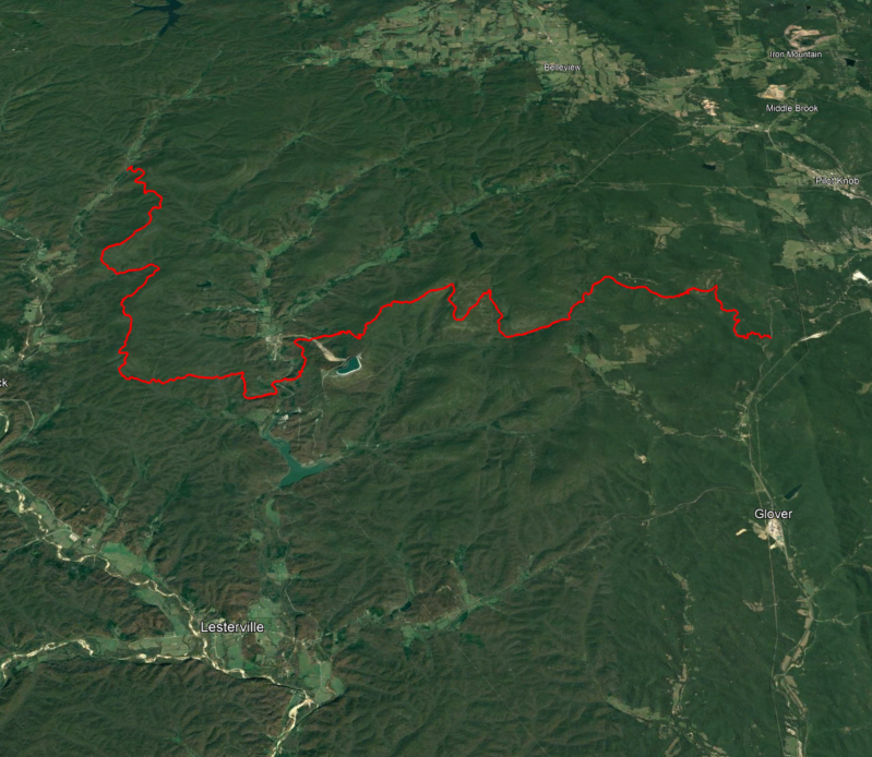
Missouri
Ozark Trail: Taum Suk section w/ Mina Sauk Falls
Friday, September 636.2 mi ✦ 5,286’ climbing ✦ 1,786’ max
A rocky and rugged point-to-point trail through the heart of the Missouri Ozarks. Highlights include the state’s highest point and tallest waterfall, igneous glades offering grand views, unusual rock formations and a flume-fed swimming hole that will surely be inviting during a grueling late-summer run.
[FlyOver] ✦ [Strava] ✦ [GaiaGPS]
Relay potential
-

Illinois
Shawnee Hills
Sunday, September 832.8 mi ✦ 3,566’ climbing ✦ 735’ max
A figure eight through the Shawnee National Forest, a technical, mostly singletrack route established by the Shawnee Hills Trail Races. Waterfalls, lush canyons, oak-hickory forest and interesting geological features.
[FlyOver] ✦ [Strava] ✦ [GaiaGPS]
Relay potential
-

Indiana
Knobstone Trail - full
Tuesday, September 1045.4 mi ✦ 5,560’ climbing ✦ 1,010’ max
A point-to-point route traversing the full-length of the Knobstone Trail—longest footpath in Indiana. A snaking tour through a mix of bottomlands and rugged ridgetops “knobs of the Knobstone Escarpment.
[FlyOver] ✦ [Strava] ✦ [GaiaGPS]
Relay potential
-

-

West Virginia
Dolly Sods Wilderness loop
Saturday, September 1427.4 mi ✦ 2,829’ climbing ✦ 4,166’ max
A rocky loop that circumnavigates the beloved Dolly Sods Wilderness of the Monongahela National Forest in the Allegheny Mountains. Forests and meadows, bogs and heath barrens. Includes an excursion to rugged beauty and grand views of Lion’s Head Rock in the interior.
[FlyOver] ✦ [Strava] ✦ [GaiaGPS]
Relay potential
Restricted Number of Runners
Route feedback thanks: Sanjay A. -

Virginia
Virginia Triple Crown Loop
Monday, September 1634.8 mi ✦ 6,774’ climbing ✦ 3,170’ max
A challenging loop stringing together three of Virginia’s Blue Ridge gems: iconic McAfee Knob, Tinker Cliffs, and Dragon’s Tooth. Not much water, some scrambling, and some overgrown sections. High bear density.
[FlyOver] ✦ [Strava] ✦ [GaiaGPS]
Relay potential
-

Delaware
White Clay Creek State Park route
Wednesday, September 1828.7 mi ✦ 3,883’ climbing ✦ 396’ max
Looping trail in rolling, mostly forested terrain surrounding White Clay Creek, a National Wild and Scenic River, at the DE/PA border. Critical bird habitat, historic sites, rocky outcroppings, and fun trails that also draw mountain bikers.
[FlyOver] ✦ [Strava] ✦ [GaiaGPS]
Relay potential
-

New Jersey
Appalachian Trail and Highpoint loop
Friday, September 2033.3 mi ✦ 3,730’ climbing ✦ 1,775’ max
Though close to major metropolitan areas, this loop has many sections that are wild and rugged and varied, much of it following the Appalachian Trail. Mostly rocky single-track traversing primarily hardwood forest, wetlands, and even an Atlantic cedar swamp. Includes the state highpoint with 360 degree views.
[FlyOver] ✦ [Strava] ✦ [GaiaGPS]
Relay potential
-

Connecticut
New England Trail
Sunday, September 2228.4 mi ✦ 5,209’ climbing ✦ 1,034’ max
A point-to-point route along the Metacomet traprock ridges where I used to run and climb and dream in my youth. A homecoming for me, and also beautiful and rugged terrain that is fun to run and transcends the population density of Central Connecticut.
[FlyOver] ✦ [Strava] ✦ [GaiaGPS]
Relay potential
-

Rhode Island
-

Massachusetts
Robert Frost Trail extended version
Friday, September 2744.5 mi ✦ 8,858’ climbing ✦ 1,406’ max
This point-to-point route is an often-stunning and constantly changing experience of some of the best trail running in Western Mass. Fun running with frequent, often unexpected wonders including crags, ponds, swamps, rock formations, and views. Part of the same rugged Metacomet Ridge as the Connecticut route. I am in good company treasuring this local trail.
[FlyOver] ✦ [Strava] ✦ [GaiaGPS]
Relay potential
-

-

Kentucky
Big South Fork Nat’l River & Recreation Area
Tuesday, October 127.2 mi ✦ 5,355’ climbing ✦ 1,427’ max
Gorgeous double loop on gorgeous single track past waterfalls, ledgy overhangs and natural arches. Historical tour through the abandoned coal mining town of Blue Heron. Several creek crossings. A Dark Sky area, so perhaps a pre-dawn start?
[FlyOver] ✦ [Strava] ✦ [GaiaGPS]
Relay potential
Restricted Number of Runners -

Tennessee
Big South Fork Nat’l River & Recreation Area
Thursday, October 328.8 mi ✦ 2,746’ climbing ✦ 1,611’ max
Elegant loop offering many ledgy overlooks of the Big South Fork of the Cumberland River and and traveling down through hardwood forests dense with mountain laurel. Hoping to add the 4.9 Twin Arches Loop Trail near mile 23. Maybe a quick visit to the backcountry Charit Creek Lodge. A Dark Sky location so perhaps we can consider an early start to enjoy the night sky, weather permitting.
[FlyOver] ✦ [Strava] ✦ [GaiaGPS]
Relay potential
Restricted Number of Runners
Route feedback thanks: Jeff D. -

North Carolina
Tricorner Knob Loop via Appalachian Trail
Saturday, October 534.7 mi ✦ 7,600’ climbing ✦ 6,310’ max
This classic loop stringing together spectacular knobs and gaps, and also sweet singletrack lined with moss through hardwood forest. Just under half if this loop follows the Appalachian Trails, and the route includes a 1.2mi out and back to Mt Cammerer Overlook for one of the best views in the Smokies.
[FlyOver] ✦ [Strava] ✦ [GaiaGPS]
Relay potential
Route feedback thanks: Jeff D. -

South Carolina
Jones Gap - Caesars Head Loop
Monday, October 728.5 mi ✦ 6,337’ climbing ✦ 3,097’ max
A challenging, often steep loop featuring several waterfalls and overlooks. Travels through oak and hickory forest, with rhododendron, ferns, and mosses flanking the often creekside trails.
[FlyOver] ✦ [Strava] ✦ [GaiaGPS]
Relay potential
-

Georgia
Chattahoochee Nat’l Forest
Wednesday, October 933.8 mi ✦ 9,269’ climbing ✦ 4,256’ max
Two loops linked by the Appalachian Trail through old forest and rugged terrain of northern Georgia. Breathtaking views, undulating and often very steep singletrack—considered a worthy representation of the southern Appalachians.
[FlyOver] ✦ [Strava] ✦ [GaiaGPS]
Relay potential
Route feedback thanks: Jeff D. -

Alabama
Cheaha Wilderness Tour with Pinhoti Trail
Friday, October 1128.4 mi ✦ 5,669’ climbing ✦ 2,332’ max
A figure eight route through varied terrain showcasing the beauty of Talladega National Forest and Cheaha Wilderness. Pinhoti, Skyway Loop, Nubbing Creek, and Chinnabee Silent Trails follow creeks past waterfalls and swimming holes under longleaf pine and oak, and traverse scenic ridges.
[FlyOver] ✦ [Strava] ✦ [GaiaGPS]
Relay potential
-

Florida
Space Coast Beach run with Four Preserves
Sunday, October 1344.1 mi ✦ 216’ climbing ✦ 39’ max
A loop(y) route heading north on one of Florida’s premier running beaches to catch the sunrise, then looping back south through several parks and preserves, sampling some of Florida’s exquisite habitats. Florida has many worthy long-distance trails, but most had a good probability of deep-water wading during October.
[FlyOver] ✦ [Strava] ✦ [GaiaGPS]
Relay potential
-

Mississippi
Black Creek National Hiking Trail
Tuesday, October 1532.2 mi ✦ 2,247’ climbing ✦ 275’ max
An out-and-back low country route loosely following the wildlife-rich Black Creek, a federally designated Wild and Scenic River. Much of this route is in the Black Creek Wilderness, hugging Black Creek in spots, and passing swamps under longleaf pines, but also including upland sections along piney ridges.
[FlyOver] ✦ [Strava] ✦ [GaiaGPS]
Relay potential
-

Louisiana
Chicot State Park w/ Arboretum trail walk
Thursday, October 1732.4 mi ✦ 1,882’ climbing ✦ 1,873’ max
A large loop around Lake Chicot with lakeside excursions throughout. Bottomland hardwood forests and gorgeous primordial cypress swamps. Small walking-only loop at the end through the Louisiana State Arboretum.
[FlyOver] ✦ [Strava] ✦ [GaiaGPS]
Relay potential
-
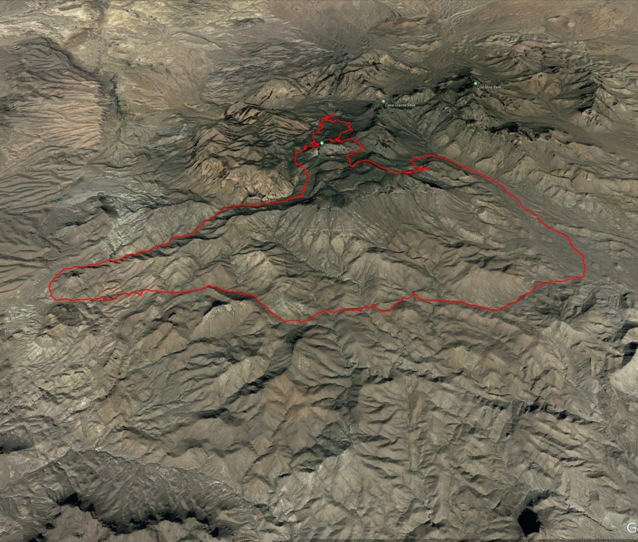
Texas
Outer Mountain Loop--Big Bend
Saturday, October 1931.8 mi ✦ 6,453’ climbing ✦ 7,069’ max
Loop in Big Bend National Park on the Mexico border is strenuous and exposed and hot and dry—safety planning, such as water caching, is essential. The route traverses the Chisos Mountains woodlands of piñon, juniper, and oak and the Chihuahuan Desert. Big Bend is an International Dark Sky Park, so perhaps an early morning start to enjoy the night sky and minimize time in the hot sun?
[FlyOver] ✦ [Strava] ✦ [GaiaGPS]
Relay potential
Restricted Number of Runners -

New Mexico
Gila Wilderness w/ hot springs and CDT
Monday, October 2135.3 mi ✦ 8,168’ climbing ✦ 7,396’ max
Super-fun slender loop through varied terrain from rolling hills to steep canyons, often following or crisscrossing creeks. Some of the route follows the Continental Divide Trail, and the canyon bottom hosts some remote and gorgeous hot springs. This area has a rich and largely unknown human history possible going back thousands of years. Running these trails feels very special.
[FlyOver] ✦ [Strava] ✦ [GaiaGPS]
No relay potential
-

Arizona
Grand Canyon Rim to Rim to Rim
Wednesday, October 2347.5 mi ✦ 12,465’ climbing ✦ 8,178’ max
Out-and-back journey through this treasure of geologic and cultural history. Super-fun running through a singularly stunning landscape. And ice-cold lemonade at Phantom Ranch! The climbing is intense, but the real challenges are cooling, hydrating, and fueling through a long day under an unrelenting sun. Maybe condor spotting?
[FlyOver] ✦ [Strava] ✦ [GaiaGPS]
No relay potential
Restricted Number of Runners -

Hawaii
Kalalau Trail w/ side trail excursions
Saturday, October 2628.7 mi ✦ 8,047’ climbing ✦ 1,244’ max
Out-and-back route along the world-famous Nā Pali wilderness coastline on Kauai. Trail undulates from beaches to the heights of steeply fluted coastal mountains. Stream crossings can become dangerous quickly, requiring waiting on water levels to fall, and trails with precipitous drop-offs are often narrow and particularly slippery when wet. The necessary vigilance is rewarded by lush vegetation, spectacular waterfalls, and breathtaking views.
[FlyOver] ✦ [Strava] ✦ [GaiaGPS]
No relay potential
Restricted Number of Runners -

Alaska
Kesugi Ridge Trail
TBD, probably late May 202530.0 mi ✦ 5,968’ climbing ✦ 3,507’ max
A spectacular point-to-point route through varied terrain, traversing lush boreal forest and exposed alpine ridge tundra. If we are lucky, and we’ll do our best to be lucky, we will have jaw-dropping views of Denali and the impossibly high skyline of the Alaska Range, often and notoriously shrouded in clouds.
[FlyOver] ✦ [Strava] ✦ [GaiaGPS]
Relay potential